Precision Aerial Surveys, Photography, and Videography in Shenandoah Valley
Unrivaled Aerial Perspective for Virginia
Shenandoah Helicopter Charters provides extensive capabilities for aerial data acquisition across Virginia, leveraging helicopters' unique low-altitude and hover proficiencies. This includes precise magnetometer and electromagnetic surveys, LiDAR data collection, and comprehensive GIS mapping. Furthermore, we specialize in advanced aerial cinematography and photography services, offering access to cutting-edge technology for visual data capture. This encompasses specialized camera systems and the operational flexibility to perform door-off shoots for handheld projects, ensuring a wide array of options for viewing and documenting the Virginia landscape from an unparalleled aerial perspective.

Aerial
Surveys
LiDAR, GIS Maps, FLIR, HD Video & More
For critical infrastructure projects, Shenandoah Helicopter Charters provides essential helicopter support, specialized equipment, and operational expertise. This includes precise pipeline integrity assessments, comprehensive right-of-way inspections, and detailed transmission line patrols. Our focus is on enabling accurate data collection and project completion across the Shenandoah Valley and wider Virginia region.
High Tech Results
The Top Pilots in Virginia, Today's Technology... Maximum Results.
Call 1-866-826-4826 Now!
Shenandoah Helicopter Charters provides the tools needed to complete your land surveys, utilizing the right equipment to provide the aerial photos that are often needed.
Effective helicopter-based aerial surveys streamline right-of-way and site inspections, facilitate precise topographical data acquisition, and enable high-definition imaging for critical commercial projects across Virginia. This methodology is optimal for pipeline integrity monitoring, identifying anomalies in transmission line infrastructure, and comprehensive property documentation. Shenandoah Helicopter Charters specializes in developing custom photographic and remote sensing operations, meticulously engineered to maximize technical and financial efficiency, while delivering demonstrably superior project outcomes for stakeholders in the Shenandoah region.
Helicopters offer inherent operational advantages for aerial surveying due to their capacity for lower-altitude flight and reduced airspeeds compared to fixed-wing aircraft. This capability circumvents the FAA's minimum altitude restrictions for fixed-wing operations, enabling significantly more precise data capture. Furthermore, helicopters facilitate safe access and detailed inspection of challenging or hazardous zones, providing engineers and project managers with critical viewpoints otherwise unobtainable, which is invaluable for infrastructure assessments across Virginia.
There is no better way to conduct your visual survey, animal population counts, soil drainage analysis, ROW inspections, pipeline and transmission line inspections, and geographical surveys.
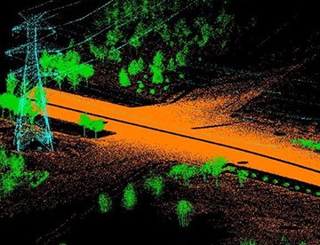
LiDAR Imaging
Light Detection and Ranging, or LiDAR, is a remote sensing method used to examine and measure Virginia topography as well as objects, like vegetation, upon it.
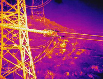
Infrared Imaging
Thermographic IR cameras are used to detect radiation in the long-infrared range of the electromagnetic spectrum and produce images of that radiation, called thermograms.

HD Video Gimbal Capture
Modern HD and 4K cameras can be mounted to helicopters, using the proper STCs, with a gimbal to stabilize photos & videos for detailed results.

Advanced Aerial Cinematography and Visual Data Capture
For expert camera work in the Shenandoah Sky
Get a Fast, free QuoteShenandoah Aerial Cinematography
Shenandoah Helicopter Charters provides access to comprehensive resources for professional-grade aerial cinematography across Virginia. We offer access to cutting-edge gyro-stabilized camera platforms, including Tyler Mounts, Wesscam, Cineflex, Pictorvision, and SpaceCam, integrated with high-performance specialty cameras such as Cineflex HD, RED Epic, and Arri Alexa, alongside options for 3D and experimental systems. Our services support all aspects of production, from air-to-air to ground-to-air shots, collaborating closely with Directors of Photography and directors to achieve precise visual objectives. Specializing in helicopter support for both still and motion photography, Shenandoah Helicopter Charters facilitates a broad spectrum of media-related operations in Virginia, including film, television, documentaries, promotional videos, commercials, aerial prop placement, media relief efforts, and comprehensive coverage of significant historical and sporting events using a diverse fleet of helicopters.
Call Us Today at 1-866-826-4826 for a Free Quote
Contact Us
Aerial Photos
Hand-held or Mounted OpTions in Shenandoah
We will help you get the right equipment for your aerial photography project! Call 1-866-826-4826 today to get a fast, free quote.
The Most Options for Photography
Capturing Virginia's distinctive landscapes and architectural subjects from an aerial perspective provides unparalleled photographic opportunities. Our helicopter charters are designed for professional photographers seeking to realize precise visual objectives. We offer operational configurations, including door-off options for handheld photography, and can provide information on specialized gyro-stabilized camera mounts for enhanced stability and precision, ensuring superior image acquisition across the Shenandoah region. Our focus is on delivering high-quality photographic outcomes for commercial and creative projects in Virginia.
Superior Service
Every one of our customers gets a dedicated helicopter expert to assist with flight plans, tech loadouts, production logistics, project schedules, and other demands.
Over 500 Aircraft
Our network of direct air partners extends well beyond Shenandoah, Virginia. This allows us to offer a wide range of solutions for even the most sophisticated projects.
The Best Equipment
From high-tech sensors like LiDAR, FLIR, and GIS to HD cameras and movie production gimbals, we're here to make your job as easy as possible.